How the Allies could have assaulted Antwerp on D-day 1944
For all you military history nerds who love to dive into the details.
Read the other articles in my series on Invasion Antwerp 1944 (an alternate military history):
Invasion Antwerp 1944 (intro article to this series)
An operational plan for assaulting Antwerp on D-day 1944 (this article)
How would Germany respond? (coming next)
It is May 1, 1944 (not June 6, as I explained here)
The Western allies have finally invaded Northwest Europe with a massive combined amphibious and airborne assault on Antwerp and southern Netherlands!
Better yet, the Allies caught the Germans completely by surprise by invading Antwerp. Hitler and the German High Command were sure that it would be Pas-de-Calais, while Rommel, the German commander of the Western front thought that it would be Upper or Lower Normandy. It turns out that they both were incorrect.
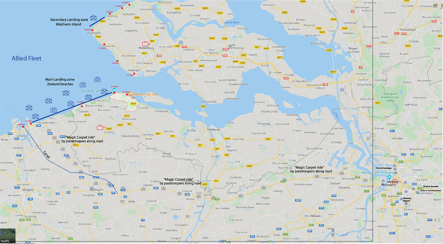
The D-day invasion in Antwerp and southern Netherlands took place in multiple phases, each of which is described below. Below is a map of the overall battlefield with the German units in red and the Allied units in blue. Each unit uses standard NATO symbology.
Unfortunately, finding good maps of this battlefield as it existed in May/June 1944 is very difficult. So in this article, I will use maps with modern Google maps as the background which include:
Post-war landfill that effectively turned Walcheren island and South Beveland island into one big peninsula (at the top of the map below)
Highways that did not exist in 1944
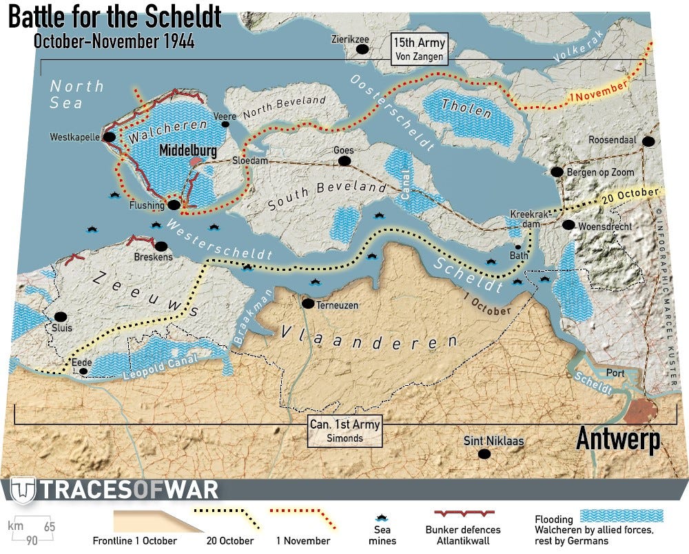
Here is what the coastline looked like in 1944, although the flooded areas were not flooded on D-day.
Note that Walcheren island was an island in 1944 whose only connection with South Beveland was a narrow causeway. Today Walcheren “island” is effectively part of the Beveland peninsula due to the post-war landfill in the channel.
Overview of plan
The plan would consist of:
Pre-invasion air interdiction campaign to trap German forces in the Pas-de-Calais region and create the illusion that Pas-de-Calais was the actual invasion target.
At dawn on D-day (May 1, 1944), air support to both amphibious and airborne troops swarm the area.
At dawn on D-day, Airborne assaults on:
The port of Antwerp (by far the most important target)
The city of Antwerp
The roads leading from the Zeeland beaches to Antwerp (to enable ground troops to capture Antwerp on D-day)
Antwerp airport (to create an airhead for reinforcement and resupply)
South Beveland island (to cut off German reinforcement of Walcheren island and path of German retreat)
Bridges and tunnels on the Scheldt river (to enable rapid advance of Allied ground troops).
On the morning of D-day, Naval gunnery support to neutralize German defenders on Walcheren island and Zeeland beaches.
At 0630 on D-day, Amphibious assault of:
4 divisions on the Zeeland beaches between Breskens and Zeebrugge
1 division to clear Walcheren island
Throughout D-day and the next few days, bombers destroy all bridges:
over the rivers/canals along the Zeebrugge-Ghent-Dendermonde line (to protect the southern flank)
over the Meuse river (to protect the southeastern flank)
(on D+4 or so) A secondary air assault and ground offensive to capture the following bridges over the Maas river (also known as the Meuse river) facing the Ruhr:
Nijmegen
Venlo
Roermond
Maastrict and Maastmechelen
(also on D+4) Follow-on forces to Brussels, Namur, and Liege (on the banks of the Meuse river). This pushes southern line to the banks of the Meuse river.
Allies begin constructing a supply chain based on Antwerp to supply further ground assaults on the Rhine river as soon as possible. Ideally, these attacks take place before Germans can rush divisions up to Rhine river.
Each of the steps is described in more detail below.
If everything went according to plan, most of Belgium and the critical bridges over the Maas river would have fallen to the Allies before the Germans could have had a chance to react. Even if it did not go perfectly, the Allies would still have the most important target on the Atlantic seaboard:
Pre-invasion air interdiction campaign
Date: starting 2 months before D-Day (weather permitting)
Goals:
Isolate German divisions defending Pas-de-Calais region so they cannot attack north in reaction to D-day invasion.
Maintain the illusion that Pas-de-Calais is the D-day target, and that Allied bombing is designed to cut off the Pas-de-Calais beaches from the rest of the Western front (i.e. the opposite of the actual plan)
Avoid all bombing in Belgium and the southern Netherlands (see more below).
Key bombing targets in:
Fortresses:
Calais
Dunkirk
Boulogne
Bridges over:
Seine river
Oise river
Railway junctions at:
Dunkirk
Lille
Amiens
It is of extreme importance not to bomb Belgium and southern Netherlands to:
Preserve strategic surprise on the actual landing region, and create the illusion that Pas de Calais is the intended target
Maintain the Belgian road, rail, and canal network for immediate use after the invasion. Note: this is exactly the opposite of what the Allies did in Normandy, which caused serious problems to Allied supply lines after July 1944.
Fortunately, these two goals complement each other quite nicely.
D-Day air support
Date: Morning of D-day
Dive-bombing of all coastal artillery installations in Zeeland and Walcheren islands. As far as I know, this was not done in the real D-day, but it seems like a wise use of military resources. If dive bombers can hit a moving ship, they should be able to hit a stationary artillery emplacement.
Low-altitude strategic bombing on:
All bridges over the Meuse river south of Maastricht. This is to cut off all German counter-attacks coming from the southeast.
Leopoldsburg camp near Beverlo (HQ of the 1st SS Panzer Division). This was by far the most dangerous German military unit in the region. A similar raid was conducted on the night of May 12, 1944. Unfortunately, it went horribly wrong. I am confident that a dawn air raid would be more accurate.
Tactical air strikes by fighters:
Antwerp airport (immediately before glider landings)
Highway between Beverlo and Antwerp (to disrupt the ability of the 1st SS Panzer Division to counter-attack Antwerp on D-day or the subsequent days).
Air support for all Allied units between the beaches and Antwerp.
Airborne Assaults
The single most important part of the operational plan is the airborne assault by 3 Allied Airborne divisions at dawn on D-day to capture Antwerp, its port, its airfield, the tunnels under the Scheldt river, and the bridges over the Scheldt river.
Airborne units on D-day (same as used in Normandy):
Airborne units deployed on D+1:
British 52nd Lowland division, trained for air landings in airports, but never actually used for that purpose. It was planned to be deployed to Deelen airport in Market Garden, but the British failed to capture the airport.
1st Polish Parachute Brigade (used in Market Garden)
The British 1st Airborne division would have remained in reserve until D+4 or so (see below).
Date: D-day
1 US Glider regiment secures the port of Antwerp (north of the city). This is the main objective of the invasion. It must be secured immediately to avoid German sabotage of port facilities.
2 British Parachute regiments assault the city of Antwerp via airdrop just east of the city walls and then immediately assaulting the city proper.
1 British Glider regiment land directly on the Antwerp airport (southeast of the city) to enable quick reinforcements and supplies via air.
2 US Glider battalions secure the two tunnels under the Scheldt river at Antwerp:
Wasslandtunnel for motorized transport
Sint Annatunnel for foot traffic (572 meters long)
4 US Parachute regiments secure the 40 miles of road between the Zeeland landing beach and Antwerp (roughly 1 Company per mile of road).
You can see the individual Parachute company units in blue stretched out along the main road on the main map at the top of the article (though they are a little hard to see).
The goal was to secure the entire stretch of road between the Zeeland beaches and the city of Antwerp, so Allied ground units could rush forward to reinforce the Airborne regiments in Antwerp.
I call this the “magic carpet ride” as it would enable the ground units to move inland far faster than without airborne support.2 US Glider battalions secure the bridge over the Scheldt river at Temse (near the bottom left of map below). This gives Allied ground units a secondary pathway to Antwerp and secures their southern flank. It also enables a rapid advance on Brussels, Namur, and Liege (on the banks of the Meuse river). This will secure the southern flank of the Allied armies.
Date: D+1 (i.e. the day after D-day) or the afternoon of D-day if feasible
When Antwerp airport is secured, fly in 1 British Air Transport Division and 1 Anti-Tank Battalion. They move to secure the eastern perimeter around Antwerp to prepare for a counter-attack by the 1st SS Panzer Division coming from Beverlo.
1 Polish Airborne battalion (from the 1st Polish Parachute Brigade lands at Woensdrecht (to cut off South Beveland island from the mainland)
1 Polish Airborne battalion lands at Goes (to clear South and North Beveland islands)
1 Polish Airborne battalion lands just east of Walcheren causeway to block the causeway and cut off retreating German units.
Air transport additional units and supplies into Antwerp airport, if possible.
Amphibious Assault
Date: D-day
Ground units that landed on D-day (same as used in Normandy), including first waves and follow-on waves:
7-8 Infantry divisions:
US 1st Infantry Division
US 4th Infantry Division
US 29th Infantry Division
US 90th Infantry Division
British 50th (Northumbrian) Infantry Division
British 3rd Infantry Division
3rd Canadian Infantry Division
elements of the British 51st (Highlands) Infantry Division
The equivalent of 2 Armored divisions:
British 79th Armored Division
British 8th Armoured Brigade
British 27th Armoured Brigade
2nd Canadian Armoured Brigade
plus many smaller units and the Airborne divisions listed above
Targets
The first unit landing on the beaches of Walcheren Island
1 Infantry Division
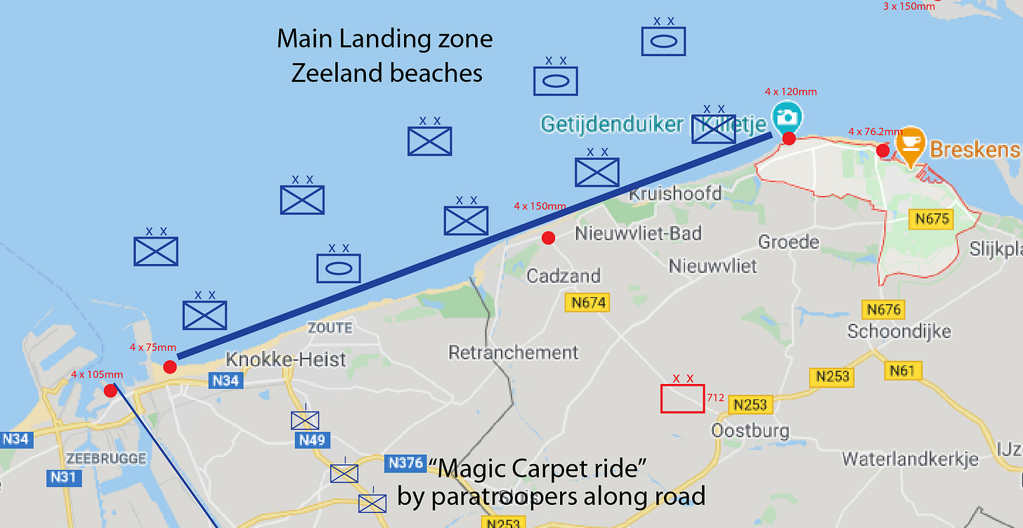
The main amphibious assault would land on the beaches of Zeeland mainland (blue line):
The key beach was at Knokke, where a highway exited the beach. That is why there is an Armored division landing at this sector. Notice also Allied paratroopers landing just off the beach to enable a swift exit from the beach.
Follow-on forces on the beaches of Zeeland mainland:
2 Armored Divisions
3 Infantry Divisions
This Allied ground force in Zeeland would have:
Overwhelming numerical superiority over German forces (at least 10-to-1 on the beaches of Zeeland)
Complete strategic and tactical surprise
Complete air superiority (from fighters and bombers)
Massive naval gunnery support
Allied naval gunnery support
Date: D-day and until Allied forces move inland beyond the range of Allied naval guns.
I will assume that the Allies use the same naval gunnery support as in Normandy. This consisted of:
7 battleships (which performed the important tasks of knocking out German coastal artillery installations)
2 monitors (same as above)
19 cruisers
38 British Fleet destroyers and 13 Hunt-class destroyers
25 US Navy destroyers
1 Gunboat
plus Allied flagships
This naval gunnery easily neutralized the German coastal artillery installations in Normandy on the morning of D-day. Given that Wacheren island and Zeeland had fewer such installations, there is no reason to believe that they would have delayed the amphibious assault or inflicted serious Allied casualties.
The naval guns then could have focused on providing support for Allies forces within range. Most likely, the focus would have been on Walcheren island, which is only 10 miles wide, well within the range of Allied naval gunnery.
The Allies could have turned Walcheren island into a pile of rubble and knocked out any threat to Allied shipping or minesweeping in the Scheldt river.
Allied bomber air support
Date: D-day only (targets switch in subsequent days)
Priority of bombing:
Destroy all bridges over rivers/canals along the Zeebrugge-Ghent-Dendermonde line. This would prevent a German counter-attack from the South and give the Allies time to build a strong defensive perimeter in Zeeland.
Attack all enemy units in Zeeland mainland or near Antwerp.
Attack all enemy units moving towards Zeeland or Antwerp.
Land Campaign (D-day to D+4)
Goals:
Rush as many Allied ground forces to Antwerp as soon as possible.
Clear both banks of the Scheldt of German forces
Build a strong defensive perimeter to the South to guard against a strong German counter-attack from Pas-de-Calais and Belgium.
To achieve Goal #1:
2 British armored and 3 British infantry divisions race from Zeeland beaches to Antwerp to support British airborne.
To achieve Goal #2:
The Polish Airborne regiment maintains a blocking position at Woensdrecht (to cut off South Beveland) and links up with British forces in the port of Antwerp. They also clear South Beveland island and North Beveland island, which is almost undefended.
The Canadian Infantry division clears Walcheren island (this is by far the most difficult challenge).
To achieve Goal #3:
4 US Infantry divisions that land after the first waves push inland and then swing southwest to push in line. The goal is to push to the Ostend-Ghent line. This would widen the beachhead and defend against any German counter-attack from the South.
Once the road to Antwerp is fully secured by Allied ground forces, 2 US Airborne and 1 US Infantry division push to the Sheldt river between Ghent-Antwerp. If possible, keep pushing towards Brussels. This will extend the southern defensive perimeter to Brussels.
D+4 Offensive
Timing: As soon as Antwerp and the Scheldt have been secured and armored forces have received follow-on supplies via the airport.
Goal
Take advantage of the chaos in the German defenses by pushing as far eastward towards the Ruhr as possible. Take the bridges over the Maas river (Meuse river), the only major geographical barrier between Antwerp and the Rhine.
Keep enough defensive troops in Antwerp and the northern/southern flanks to defend against German counter-attack and protect the Allied supply chain.
Follow-on Airborne assault
Think of this as the Market Garden phase of the plan. The airborne directly assaults bridges far behind the front lines, and the ground units rush to save them. The difference is that while Market Garden needed to secure about a dozen bridges, my plan involves only three bridges over the same river. Only one of which needs to succeed for the plan to succeed. This make my plan far less risky.
The British 1st Airborne division (which was in Market Garden) assaults the bridges over the Mass river that led towards the critical Ruhr region. One Glider battalion and one Parachute regiment each capture the key bridges at:
Venlo
Roermond
Maastmechelen
The fourth major bridge over the Maas is in Nijmegen, Netherlands. This bridge was a major target of Market Garden. Since the goal of the Allied operations was to cut off the Ruhr region as soon as possible, crossing the Nijmegen bridge was not necessary as it was too far north. It was only necessary to stop German reinforcements from crossing, so there was no need for airborne assault.
Follow-on ground assault to bridges over Maas river
One Armored and one Infantry division push to each of the following cities on the banks of the Maas river:
Breda > Tilburg > s’ Hetogenbosch > Nijmegen bridge over Maas river
(87.7 miles from Antwerp). Nijmegen is just north of the map above.Turnhout > Eindhoven > Venlo bridge over Maas river
(86.0 miles from Antwerp)Herentals > Lomme > Weert > Roermond bridge over Maas river
(81.3 miles from Antwerp)Aarschot > Hasselt > Maastrict and Maastmechelen bridge over Maas river
(69.0 miles from Antwerp)
Follow-on ground assault secure southern flank
Three US Infantry and three Airborne divisions push south to Brussels, Namur, and Liege (on the banks of the Meuse river). This will anchor the eastern flank of the Allied southern defensive perimeter on the Meuse river (whose bridges were already destroyed by the D-day bombing campaign).
4 US Infantry divisions continue pushing to the Ostend-Ghent line (see map above). This strengthens the Allied southern defensive perimeter.
One British Airborne division remains behind to defend Antwerp.
The Result?
Freedom Antwerp!
By D+10, Allied forces should control:
The northern half of Belgium
All of the Netherlands south of the Maas river.
In addition, Allied forces have a:
A secure southern flank (the Ostende-Ghent-Brussels-Namur line)
A secure southeastern flank (along the Maas/Meuse river)
A secure western flank (along the North sea)
with plenty of time to move additional troops up the Maas river.
Most importantly, Allied forces would have control over all three bridges over the Maas river facing the critical Ruhr region. Now only the Rhine river barrier was left, and it was still only mid-May 1944. There is still at least six months to cross the Rhine before the winter of 1944/45.
Hitler is crapping in his pants!
Read the other articles in my series on Invasion Antwerp 1944 (an alternate military history):
Invasion Antwerp 1944 (intro article to this series)
An operational plan for assaulting Antwerp on D-day (this article)
How would Germany respond? (coming next)


